3D Rapic moved the radar display system beyond the traditional PPI display format
that had lasted over 40 years. A Silicon Graphics workstation was chosen in
the early 90's as the platform to present the three dimensional data gathered
by a mutiple elevation suite of radar sweeps. The same Rapic Transmitter was
programmed to gather this volumetric data and better communication services
were required to transmit the larger amounts of data sent with every 10 minute
update.
GENERAL DESCRIPTION
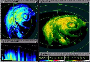
3D-Rapic is a display system designed specifically for the display of volumetric
(3 dimensional) weather radar data.
The display allows the volumetric data to be viewed in a number of different
ways, such as PPI , RHI , Echo Tops , VIL (Vertically Integrated Liquid), CAPPI
etc. through windows on the display screen. A number of different representations
may be simultaneously displayed on the display screen.
OPERATION
Display and Sequence Controls.
3D-Rapic allows a number of radar product display windows to be open concurrently.
These may be used to offer different methods of viewing the radar data, as well
as to allow data from multiple radars to be viewed con-currently.
Primary control of the 3D-Rapic display is through the Rapic Control Panel.
This control panel contains the basic sequence controls such as Stop, Start,
Step, Oldest, Latest, and also the main menus which provide to access all of
the more detailed sequence options, the database interface and the communications
interfaces.
Display Windows.
Some of the various displays available in 3D Rapic are
* PPI - Plan Position Indicator, constant radar elevation view.
* RHI - Range Height Indicator, constant radar azimuth view
* Echo Tops - product calculated from the volumetric data to show highest echoes
that exceed a given threshold, color coded and 3D rendered according to height
* VIL - Vertically Integrated Liquid, product calculated from the volumetric
data to show mass of water in a column above the earth's surface. Units of kg/m
2
* CAPPI - Constant Altitude PPI, assembled from the pieces of each PPI scan
closest to the desired altitude.
* various vertical cross section modes
With all windows, mouse movement, in conjunction with holding down of one or
a combination of mouse buttons provide such window control operations such as
zooming, panning and 3D rotational view angle control.
Rainfall Accumulation Display
3D-Rapic can be configured to calculate rainfall accumulation products for user
specified radars and periods. The accumulation is displayed by a PPI window
by switching the window into accumulation mode. Where accumulations from multiple
radars are being performed, it is possible to display merged rainfall accumulation
PPIs.
The rainfall accumulation product is currently calculated at 1 km range resolution
to a maximum range of 256km.
Database
3D-Rapic has an integrated database system which stores all incoming radar scans.
The scans from the database are available for review through an easy to use
database browser.
The database files build up to 50 megabyte size and then automatically that
database closes and a new database. is started. The database clears itself before
it runs out of hard disk space.
A file (rpdb_path) specifies how many 50 megabyte files are held before the
database is cleared.
COMMUNICATIONS
3D-Rapic has an integrated communications system which allows either volumetric
data, and/or standard surveillance data, from a number of radars, to be ingested.
Radar data may be accessed directly from a radar, or it may be requested from
another 3D-Rapic display which buffers the data it receives and makes it available
for other display systems. This mode of operation is known as splitting, and
is of particular value where volumetric data from a single radar is required
at more than one display site, as the Rapic radar communications system at a
radar site can only support one volumetric communications connection at a time.
A scheduler is also provided which will periodically interrogate radar data
3D-Rapic uses one or more communications handlers, each of which can either
be dedicated to collecting data from a single radar, or be available in a pool
for servicing requests for data.
Dedicated radar connections (typically for volumetric data), communications
request handlers and radar sites available for interrogation are configured
by the 3D-Rapic administrator in a communications initialisation file.
MAP OVERLAYS
Two forms of map overlays are supported.
The radarname.MAP binary map files which contain three maps for the 128km, 256km
and 512km+ ranges. The *.MAP files need to be created through the Windows RAPIC
Map Editor developed originally for PC-RAPIC.
The ASCII Lat/Long file type uses the MAPGEN format. This format being the default
for USGS Coastline Extractor - which is one of the world's largest shoreline
databases, allows easy creation of map databases. The files are of the form
radarname.mp1.
A special map global.map can be used to provide a single ASCII Long/Lat map
for merged images.
References
1. 3D- Rapic
Users Manual